
Additional Historical Drilling Results Confirms Tundulu REE Potential

DY6 Metals Ltd (ASX: DY6) (“DY6”, “the Company”), a strategic metals explorer targeting Heavy Rare Earths (HREE) and Niobium (Nb) in southern Malawi, is pleased to report the results of historical drilling that confirm the potential for the Tundulu Project to host significant rare earth elements mineralisation.
HIGHLIGHTS
- Additional data includes 7,000m of drilling (55 holes) undertaken at the Tundulu Project, southern Malawi
- Results confirm Tundulu’s potential as a significant REE project enriched in REE- mineralised carbonatites
- Exceptional high-grade intercepts include:1
- 101m @ 1.02% TREO, 3.6% P2O5 from surface (TU030)
- 91m @ 1.09% TREO, 7.6% P2O5 from 46m (TU026)
- 85m @ 1.04% TREO, 2.0% P2O5 from 22m (TU025)
- 109m @ 1.06% TREO, 3.7% P2O5 from 53m (TU035)
- 100m @ 1.09% TREO, 12.6% P2O5 from 30m (TU042)
- 97m @ 1.35% TREO, 14.4% P2O5 from surface (TU050)
- 125m @ 0.82% TREO, 2.3% P2O5 from 54m (TU078)
- 95m @ 1.21% TREO, 0.92% P2O5 from 25m (TU110)
- 87m @ 1.19% TREO, 0.43% P2O5 from 5m (TU071), including 15m @ 3.46% TREO from 73m
- 74m @ 1.55% TREO, 4.4% P2O5 from 72m (TU043), including 11m @ 2.56% TREO from 84m
- 31m @ 2.27% TREO, 0.64% P2O5 from 41m (TU048)
- 30m @ 4.03% TREO, 0.35% P2O5 from surface (TU014)
- Drilling averaged 127m drill depth, with multiple holes ending in mineralisation (TU105B, TU110, TU094, TU087, TU073)
- REE mineralisation remains open towards southern and western directions of Nathace Hill and potentially extends beyond the boundaries of the previously established mineralised area over Tundulu Hill
- Results of recent reconnaissance sampling program align with historical data with visual observation of multiple carbonatite outcrops across the Tundulu project area
- Mineralogy and metallurgical assessment of recent comprehensive reports are underway using experienced REE and phosphate processing consultants in Perth with the aim to commence beneficiation test work in Q3
- Grant of Tundulu licence expected imminently
Historical drill data
The campaign conducted in 2014 comprised 55 holes for 7,000m of drilling (Figure 1).
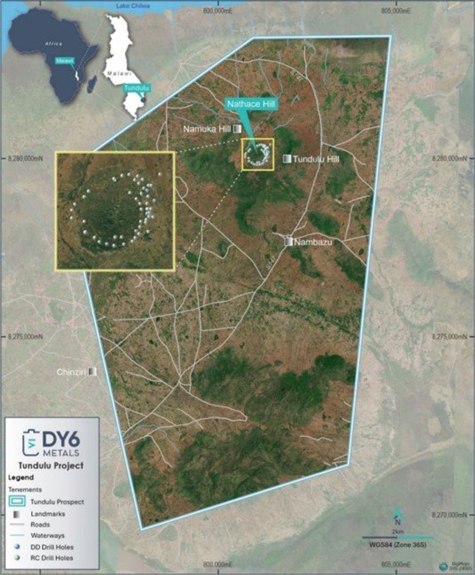
Figure 1. Tundulu Project Location Map and Historical Drill Hole locations over Nathace Hill
This information builds on shallow historical drilling undertaken by Japanese International Cooperation Agency (JICA) in 1988 (up to a max depth of 50m), which included 41m @ 3.7% TREO, from 8m (JMT- 22) (refer DY6 ASX announcement dated 11/12/23). DY6 continues to compile an extensive exploration database at Tundulu and Nathace Hill comprising geological, geochemical, and geophysical data along with detailed geological mapping and surface sampling which identifies a large REE and apatite-hosted mineralised system.
Tundulu is formed of several hills in a ring around a central vent called Nathace Hill where the majority of the historic surface sampling and drilling was undertaken. The predominate geology at Nathace Hill is REE apatite, REE carbonatites and feldspathic breccia, and comprises a large inner agglomerate vent. Mineral rich carbonatite also occurs at Tundulu Hill east of Nathace and Makhanga Hill west of Nathace and is previously unexplored and prospective for REEs (Figures 2 and 3).
Click here for the full ASX Release
This article includes content from DY6 Metals, licensed for the purpose of publishing on Investing News Australia. This article does not constitute financial product advice. It is your responsibility to perform proper due diligence before acting upon any information provided here. Please refer to our full disclaimer here.
Source : https://investingnews.com/additional-historical-drilling-results-confirms-tundulu-ree-potential/